
New York City’s election of Mayor Eric Adams, a former New York Police Department lieutenant with a pro-police agenda, signaled to many a setback in a political movement that began in 2020 and called to defund police departments. But the movement goes beyond calls to defund—it requires investment in community-based institutions and practices for transformative justice that address harm and conflict while interrupting cycles of crime and disruption caused by incarceration (Kaba 2021).
The mayor’s office has minimal jurisdiction over major policy areas that can address underlying inequities, however. Uneven distribution of power between the mayor, state government, city council, and the police, including its unions, ultimately lead to reinvestments in policing (Durkin and Goldenberg 2021). So goes the saying, to a hammer everything is a nail. The most powerful hammer that the mayor has is the NYPD. And so, the mayor refracts every problem through the lens of crime, policing, and incarceration.
The Office of the Mayor is not a countervailing institution to police power (Vitale 2017). But the New York City Council, with its own democratic mandate and members with local support and relationships, could be. Current political geography, however, makes such a role elusive. Observing spatial mismatch (Solís et al. 2016) between police precincts and the boundaries of council districts alongside the concentration of power between the mayor and NYPD, I hypothesize that a network burden on individual city council members prevents local accountability for police violence, misuse of funds, and the mayor’s overreliance on the NYPD that might produce systemic change. The 2023 Districting Commission should consider how the new district map could better support the council to make critical interventions against policing as policy solution.
Political geography of representation and policing at the city level
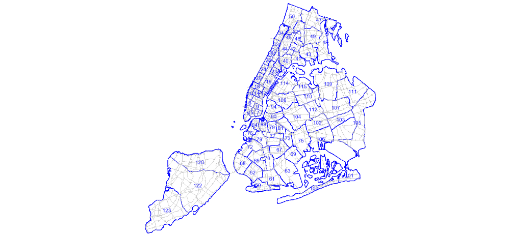
NYPD precincts overlap with the city’s 71 community districts, which are compact geographic areas corresponding to groupings of neighborhoods (Figure 1). Each community district is represented by a community board. While they are included in some government processes like rezoning, and are consulted for local NYPD leadership appointments (Gartland and Tracy 2021), community board members are appointed, not elected, and their opinions are not legally binding. Precinct community councils, while more targeted towards police–community relations, are volunteer-based, with even less formal power. Beyond precincts, the NYPD uses CompStat, a mapping-based crime data program, to structure its work and distribute resources, coding urban space in terms of crime.
© Toby Irving.
Meanwhile, density and demographics in New York City can change from block to block, making representative, coherent political boundaries for council districts elusive. The New York City Council is not a particularly powerful legislature, facing the same issue of state control over most policies. But their primary roles, currently, are approval of the city budget and land use, alongside various oversight functions regarding use of those funds. I focus on the city council due to three unique features: members are democratically elected (as opposed to appointed or volunteer-based, like precinct councils and community boards); they fund all city agencies, which includes the NYPD; and they work with leaders and organizations beyond the police, which improves neighborhood safety. Because of the council’s influence over agency budgets and their own discretionary funds, individual council members often become champions for the local and citywide organizations that address core issues like job training, youth development, and services for the homeless. The council is thus able to see the city and address its problems through a wide variety of policies and programs, a dynamic view of their communities and institutions at odds with the limited frame of crime and punishment. Where a councilmember might identify the needs of a constituent in terms of housing, employment, education, and healthcare, the NYPD, with whom the constituent is more likely to interact on a daily basis, can only act as an agent of the criminal legal system.
Spatial mismatch and network burden
Drawing on political geography theory, this research asks: how do different government institutions’ spatial boundaries, responsibilities, and orientations impact distribution of power across government? It is inspired by a broader hypothesis that neoliberal regimes of urban governance (Harvey 1989; Hackworth 2007; Brown 2017) create complexity in local government and direct service provision that diminishes the authority of the people over state actors.
Spatial and scale mismatch emerge from the geography literature to grapple with ontological and practical problems regarding management of space and resources. The Decision-Making/Accountability, Spatial Incongruence Problem (DASIP) identifies three primary challenges, including that “the spatial unit and scale to which decision makers are held accountable for such decisions may furthermore be incongruent with either data, decisions, or impact” (Solís et al. 2016). The incongruence between precinct and district maps, despite the council’s budgetary authority, limits potential to influence localized and street-level decision making by police (Lipsky 1980), and serves to reinforce the primary relationship between the mayor’s office and the NYPD and its unions that leads to overreliance on policing.
In addition to the spatial incongruence in these maps, a given district is likely to overlap with so many different precincts, and thus layers of internal hierarchies and practices designed to protect police, that meaningful local, middle-management intervention is unfeasible. I define this dynamic as network burden, wherein elected officials are at the nexus of so many government entities, individuals, and policies that their role and democratic mandate becomes diffuse, threadbare, and ineffective.
A given precinct can narrowly concentrate its efforts and considerable resources in a community, whereas a corresponding councilmember is responsible for responding to the same neighborhood problems with an ultimately burdensome need to coordinate across multiple geographic and systemic areas. Without a pathway to reconcile these relationships to urban space governance, and empower community-based, democratic leadership, the NYPD will continue to entrench disproportionate, racialized criminalization through its exercise of power.
Data and the case of District 35
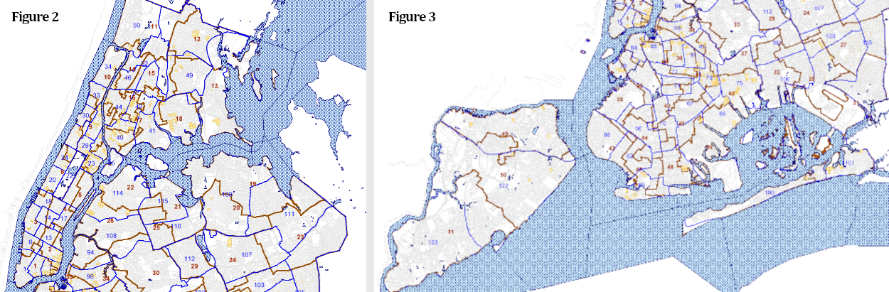
The maps below layer New York City Council districts, NYPD police precincts, and the locations of New York City Housing Authority campuses and properties.
© Toby Irving.
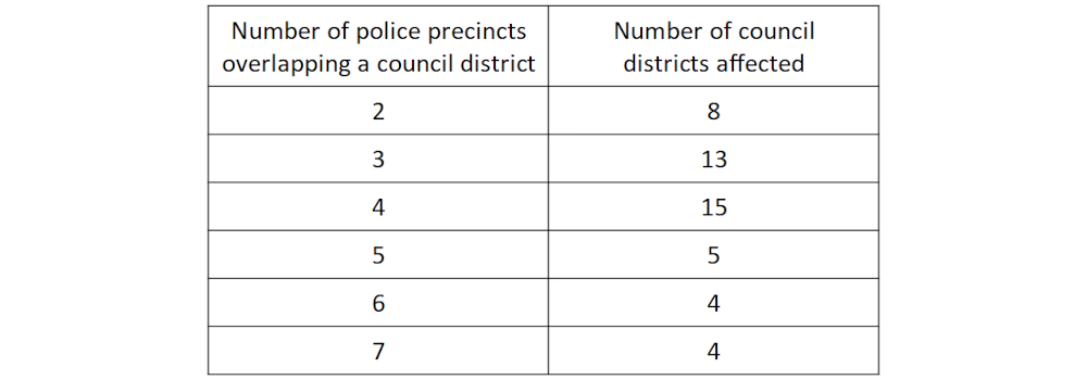
Figures 2 and 3 layer police precincts with the 2013–2023 council districts. Table 1 contains a breakdown of how district and precinct boundaries present a network burden on city council members. Some 60% of council districts overlap with at least four different police precincts, with 25% overlapping five or more. The maps also include the locations of public housing campuses, which often contribute to district density, are sites for community policing efforts (Umbach 2011), and remain heavily-policed high crime areas (Smith 2021).
© Toby Irving.
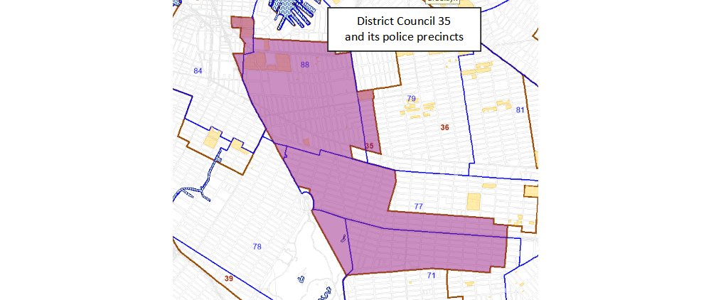
With the introduction of term limits on council members beginning in 2016, the population of the city council has shifted significantly. But the election of Mayor Adams is the product, at least in part, of a long-standing power center of black democratic politics in Brooklyn. Given the transition to his administration and the demise of the popular defund movement, District 35 and its representative from 2013-2020, Laurie Cumbo, now a member of Adams’ administration, provides a good example. District 35 includes historic black neighborhoods Crown Heights and Fort Greene.
© Toby Irving.
At first glance, District 35 overlaps substantially with three precincts: 88, 77, and 71. However, two additional precincts police two public housing campuses: one in the 79th and one in the 84th. If there were to be an incident of police violence on either of these campuses, community members, including those active on the community board and other local leadership, expect their representative to act. Prior to an incident, Cumbo would not necessarily have a relationship with those precincts, making her vulnerable to defaulting to police authority. If the administration of policing lined up with the administration of all other council-funded business, from youth development to jobs programs, Cumbo might have the relationships and knowledge to counter that authority and problem-solve more effectively.
More broadly, if councilmembers had more capacity to directly represent clusters of residents who find themselves at odds with police, how might this change the landscape of the policy network, from the office of the mayor to the powerful police unions? It is impossible to entertain such possibilities when councilmembers in the city’s densest neighborhoods are expected to negotiate with up to seven precincts.
Implementation
The Districting Commission for 2023, and any future redistricting, would have needed more information to determine what exactly a better map would look like (Bucarey et al. 2015) to address spatial mismatch and network burden and increase the council’s influence over the NYPD. An interorganizational analysis (Thatcher and Braunstein 2015) would more comprehensively explain the consolidation of power regarding policing at the city-wide level, especially regarding police unions. This might also illuminate what more localized accountability would offer in terms of systemic change.
Moving forward with the new council map in 2024, a rigorous network analysis explaining the relationships among leadership at the citywide level could inform policy to dismantle an intransigent power structure. Adam and Kriesi’s typology of network structures considers the distribution of power in a network (concentrated or fragmented) and its relationship to interactions involving conflict, bargaining, and cooperation (Adam and Kriesi 1999, p. 135). To develop capacity for accountability, with or without a more advantageous map, the council needs a more thorough understanding of the intra-organizational structure of the NYPD, from precincts to larger geographically based commands and targeted enforcement groups.
Maya Mynster Christensen and Peter Albrecht “argue that urban policing principally is a practice of bordering, understood as spatial and relational practices that occur through processes of translation and negotiation. Further, we propose that borders and bordering practices, in their material, symbolic and imaginary sense, are constitutive of the city [Lazzarini 2015, p. 177], and emblematic of the volatility and instability that shape the production and transformation of urban space [Roy 2011, p. 8]” (Christensen and Albrecht 2020). They suggest ethnographic methods to investigate the exchange of influence between urban space and policing. To develop more people power in the face of the NYPD’s dominance, the voices of councilmembers, both past and current, are needed to elucidate the realities of network burden. The recently revamped progressive caucus of the city council committed “to reduce the size and scope of the NYPD and the Department of Correction,” (“Statement of Principles”; PCNYCC 2023) and such an investigation could further their goals.
Bibliography
- Adam, Silke and Kriesi, Hanspeter. 1999. “The Network Approach” (Chap. 5), in P. A. Sabatier (ed.). Theories of the Policy Process, Boulder: Westview Press.
- Bucarey, Victor; Ordóñez, Fernando; and Bassaletti, Enrique. 2015. “Shape and Balance in Police Districting”, in H. A. Eiselt and V. Marianov (eds.), Applications of Location Analysis, Cham: Springer International Publishing, pp. 329–347.
- Brown, Wendy. 2017. Undoing the Demos, Princeton: Princeton University Press.
- Christensen, Maya Mynster and Albrecht, Peter. 2020. “Urban Borderwork: Ethnographies of Policing”, Environment and Planning D: Society and Space, vol. 38, no. 3, pp. 385–398.
- Durkin, Erin and Goldenberg, Sally. 2020. “Longtime Supporters Dismayed at de Blasio’s Shift from Police Reformer to Defender”, Politico, 1 June. Available online at the following URL: www.politico.com/states/new-york/albany/story/2020/05/31/longtime-supporters-dismayed-at-de-blasios-shift-from-police-reformer-to-defender-1289640.
- Gartland, Michael and Tracy, Thomas. 2021. “NYC Community Groups to Play Formal Role in Hiring of NYPD Precinct Commanders: de Blasio.” New York Daily News, 28 January. Available online at the following URL: https://www.nydailynews.com/2021/01/28/nyc-community-groups-to-play-formal-role-in-hiring-of-nypd-precinct-commanders-de-blasio.
- Hackworth, Jason. 2007. The Neoliberal City: Governance, Ideology, and Development in American Urbanism, Ithaca: Cornell University Press.
- Harvey, David. 1989. “From Managerialism to Entrepreneurialism: The Transformation in Urban Governance in Late Capitalism”, Geografiska Annaler: Series B, Human Geography, vol. 71, no. 1, pp. 3–17. DOI: https://doi.org/10.1080/04353684.1989.11879583.
- Lipsky, Michael. 1980. Street-Level Bureaucracy: Dilemmas of the Individual in Public Service, New York: Russell Sage Foundation.
- Progressive Caucus of the New York City Council (PCNYCC). 2023. “Statement of Principles”, February. Available online at the following URL: https://nycprogressives.com/statement-of-principles.
- Solís, Patricia; Vanos, Jennifer K. and Forbis, Jr., Robert E. 2017. “The Decision-Making/Accountability Spatial Incongruence Problem for Research Linking Environmental Science and Policy”, Geographical Review vol. 107, no. 4, pp. 680–704, October. DOI: https://doi.org/10.1111/gere.12240.
- Thatcher, Mark and Braunstein, Jueren. 2015. “Issue Networks: Iron Triangles, Subgovernments, Policy Communities, Policy Networks”, International Encyclopedia of the Social and Behavioral Sciences. pp. 769–773.
- Vitale, Alex S. 2017. The End of Policing, New York: Verso.
Further reading
- Borgström, Sara; Elmqvist, Thomas; Angelstam, Per; and Alfsen-Norodom, Christine. 2006. “Scale Mismatches in Management of Urban Landscapes”, Ecology and Society, vol. 11, no. 2, art. 16. Available online at the following URL: https://ecologyandsociety.org/vol11/iss2/art16.
- Communities United for Police Reform and cosignatories. 2021. “Re: Pre-considered resolution adopting parts of Mayor de Blasio’s policing plan, related to Governor Cuomo’s executive order 203”, open letter, 25 March. Available online at the following URL: www.changethenypd.org/sites/default/files/letter_to_nyc_council_re_resolution_on_the_de_blasio_policing_plan.pdf.
- Derudder, Ben and Neal, Zachary. 2018. “Uncovering Links Between Urban Studies and Network Science”, Networks and Spatial Economics, vol. 18, no. 3, pp. 441–446.
- Graif, Corina; Gladfelter, Andrew S.; and Matthews, Stephen A. 2014. “Urban Poverty and Neighborhood Effects on Crime: Incorporating Spatial and Network Perspectives”, Sociology Compass, vol. 8, no. 9, pp. 1140–1155.
- Gill, Charlotte; Weisburd, David; Telep, Cody W.; Vitter, Zoe; and Bennett, Trevor. 2014. “Community-Oriented Policing to Reduce Crime, Disorder and Fear and Increase Satisfaction and Legitimacy among Citizens: A Systematic Review”, Journal of Experimental Criminology, vol. 10, pp. 399–428.
- Lazer, David. 2011. “Networks in Political Science: Back to the Future”, PS: Political Science and Politics, vol. 44, no. 1, pp. 61–68.
- Ransom, Pamela and Wai, Sidique. 2017. “Fostering Community Engagement: Reinvigorating Community Precinct Councils in New York City”, The Police Journal, vol. 90, no. 3, pp. 261–273.


